


Sölden - Schwarzsee

i20
User
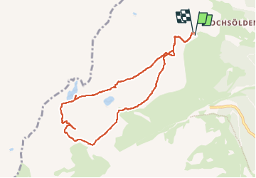

Length
8.5 km

Max alt
2843 m

Uphill gradient
599 m
Km-Effort
16.5 km

Min alt
2271 m

Downhill gradient
598 m
Boucle
Yes
Creation date :
2022-07-31 10:58:38.459
Updated on :
2022-07-31 14:13:22.523
3h01
Difficulty : Medium

FREE GPS app for hiking
 SityTrail
IGN / Geographical institutes
SityTrail Plus
The world is yours!
About
Trail Walking of 8.5 km to be discovered at Tyrol, Bezirk Imst, Gemeinde Sölden. This trail is proposed by i20.
Positioning
Country:
Austria
Region :
Tyrol
Department/Province :
Bezirk Imst
Municipality :
Gemeinde Sölden
Location:
Unknown
Start:(Dec)
Start:(UTM)
650264 ; 5204315 (32T) N.
Comments